|
The Bourne
Castle excavations of 1861
The archaeological dig of 1861 was not
intended as a serious excavation of the site but rather as a sideshow or
entertainment for delegates and visitors to the annual meeting of the Lincoln
Diocesan Architectural Society.
The organisation represented many people with interests in their heritage and
annual meetings were rotated to various towns around the county. In the summer
of that year, Bourne was chosen as the host venue, due mainly to the
enthusiasm and encouragement of one of its members, Robert Mason Mills, founder
of the town’s aerated water business and a dedicated antiquarian who was deeply
fascinated by the history of the locality.
On Monday 8th April 1861, the Rev Edward Trollope, the society’s honorary
secretary who was organising the event, visited Bourne to make the preliminary
arrangements and to select various sites for the members to visit. These
included Bourne Abbey, the ruins of the Valli Dei (Vaudey) Cistercian Abbey in
the grounds of Grimsthorpe Park, the temple of the Hospitaller Knights at
Aslackby and the site of Bourne Castle. Unfortunately, the only remains of the
latter were a few bumps and hillocks in the field off South Street and so it was
arranged that a superficial dig would begin as an added attraction although it
would appear that this would consist of nothing more than lifting off the
surface soil in an attempt to reveal the foundations or any remaining stonework,
if indeed it did exist.
The society could not afford detailed excavations and neither were they planned
and it was intended that the search would take place only over a few days to
coincide with the meeting which was fixed for Wednesday and Thursday, 5th and 6th June 1861.
By Saturday 11th May, a working committee had been appointed and was busy
finalising the itinerary, the prospect of the castle excavations now exciting
great interest because at that time its reputation as the home of Saxon kings
Morcar, Oslac and Leofric, was well known although the more famous connection
with Hereward the Wake was not popularised until five years later when Charles
Kinglsey wrote his famous novel in 1866, basing his account on the romantic
tales recounted in certain mediaeval chronicles, suggesting that he was the son
of the Earl of Leofric and his wife Lady Godiva who owned the manor of Bourne
and the castle in the Wellhead field which became known as Hereward's
birthplace.
By this time, the itinerary for the visit was becoming extensive and more people
were co-opted on to the organising committee which then formed two separate
sub-committees, one to superintend the arrangements at the Town Hall from where
the events would be directed, and the other to take over the management of the
railway goods warehouse in South Street which the railway company had agreed
could
be converted for use as a museum and lecture hall and it was also within easy
reach of the site of the proposed excavations. By this time, the programme for
the two-day event had been provisionally drawn up and it was so varied and
interesting that a large gathering was anticipated.
The local Rifle Corps was recruited to hold a parade through the town on the
first day, Wednesday, and after marching to the Abbey Church for a service,
everyone gathered at the castle site for a lecture on its history, although
admission was by ticket only. There was a brass band to provide music and
visitors later moved to the temporary museum to inspect the displays and hear
lectures on various topics. There was a
public tea that day and a dinner on the Thursday and as the organisers
anticipated, the events on both days were crowded.
Excursions were arranged for visitors to see all of the important sites and
historic buildings in
Bourne and the surrounding villages using a succession of horse-drawn carriages
leaving at regular intervals and all were busy throughout the two days. The tour
on Wednesday took in the north of Bourne, including Dunsby, Dowsby, Sempringham,
Billingborough, Horbling, Threekingham, Folkingham (where there was a stop of 20
minutes to inspect the remains of the Aslackby Preceptory), Rippingale, Haconby
and Morton. On Thursday the route took visitors south though Thurlby, Baston,
Langtoft, Market Deeping, Northborough, Peakirk, Crowland and Deeping St James.
Excavations on the castle site had begun on Monday 27th May and the only
objective was to lay bare some of the foundations and it is therefore worth
remembering that the team for this examination of an important archaeological
site consisted of little more than a few men with shovels. When the event was
over, the soil was replaced and a report on their progress drawn up. It said:
“Nearly half the moat which surrounded the castle on the south side is still in
existence. On the west side of the field, and close to the inner edge of the
moat, the workmen discovered a substantially built wall, about four feet thick,
which is supposed to have been the place where the drawbridge stood at the time
the castle was occupied.”
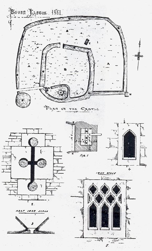
The committee decided that this was insufficient and so they commissioned a more
extensive and imaginative report on what they had found, suggesting that the remains of two circular
towers had been uncovered, a short distance to the west of the earthen mound
that can still be seen in the Wellhead Gardens. The report said that the walls of these towers were at least three
feet thick and the distance between them 16 feet 6 inches and that the towers formed the gatehouse to the inner bailey, or courtyard, in which
stood the keep on the mound of earth. The dig also revealed timbers in a sunken
chamber near the gatehouse and these were thought to be part of the leverage for
raising the drawbridge over the moat that surrounded the inner bailey. Opposite
the gatehouse, below the soil, were the remains of a wall that may have served
as the support of the drawbridge when let down and if this was correct, then the
moat would have been 44 feet wide at this point.
To complete their reconstruction of the castle,
the archaeologists of 1861 suggested that an outer bailey covered an area of
about eight acres and was bounded by St Peter's Pool and the course of the
Bourne Eau, right round from the pool to what is now South Street, and so a
second or outer moat was created. The keep was therefore protected, on the south
by a single moat running close beside it, and on the other three sides by two
moats, one fairly close by and the other at some distance, the latter being in fact the river itself.
All of these features have been mentioned by previous historians but none
verified by archaeological evidence.
One further fact was noted in 1861: that certain stones that were built into the end of a nearby barn were the exterior parts of crossbow slits that had once been part of the castle walls. These stones can still be seen today in what is now the Shippon
Barn that stands close to the footpath across the Wellhead Gardens but their
provenance is suspect, the stone, particularly in the so-called crossbow slits,
having little appearance of the age required to fit this theory.
A plan of the castle by James Fowler, based on a drawing by a
local enthusiast, Robert Parker of Morton, has subsequently been used by local
historians as proof that a castle existed at this point but the reconstruction
of the layout of the entire building appears to have been inspired by the 1861
excavations. The conclusions were also given some credence when
members of the Lincolnshire and Nottinghamshire Architectural Society visited
Bourne in 1889. Shortly before their arrival, some of the remains, purportedly the gatehouse,
had been laid bare for their inspection and the outline of a round tower was
discernible and it was presumed that the other tower had also existed, as was
stated in 1861, but the timbers for raising the drawbridge had apparently been
lost.
No other evidence is available as to the
existence of a castle in Bourne. The site in the Wellhead Gardens is now a scheduled ancient monument but there have been suggestions in recent years that further excavations should be carried out in an attempt to throw more light on the origins of the castle
and to lay to rest the various myths and legends that surround it. Whatever is found could then be developed as a tourist attraction and educational resource but the
trustees of the Bourne United Charities which owns the land have refused such permission and are opposed to any further excavations.
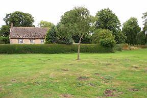
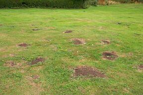
A long dry spell during the summer of 2005
revealed evidence of human occupation on the parkland where a combination of close
mowing and a lack of rain produced a large number of circular patches of bare
earth where the grass had died through lack of moisture, clearly showing the
outline of a large building or buildings that once stood on the spot. A second
set of patches also appeared to the west and these were thought to indicate
another important structure.
There was a similar occurrence during drought conditions in August 1990 but the
latest manifestation was far more detailed and welcomed as an indication of the
exact location of Bourne Castle. In the middle of it all stood a silver birch,
planted 30 years ago but still stunted in growth because it had never reached
the maturity of other trees in the vicinity that were planted at the same time,
perhaps indicating low soil levels on top of stone that had caused the grass to
die off in patches while the surrounding area remained green.
It is a romantic idea to believe that the signs revealed by the dry weather
could be evidence of the castle but it is part of Bourne’s history and that is
how the discoveries will most probably be regarded. Cyril Holdcroft, who
lives nearby in South Street, was in no doubt about their provenance and
optimistic that they were evidence of the existence of a castle. “The patches
indicate where the towers were situated and this is exciting because until now
it was not known exactly where it was located,” he said.
Mr Holdcroft, aged 84, a retired cabin services director with British Airways
who has lived in Bourne since 1939, was convinced that a detailed aerial survey
followed by an archaeological dig would produce firm evidence of the stone walls
of the castle, parts of it, perhaps the top sections of the battlements, so
close to the surface that the grass had dried up and died during long spells
without rain. This theory was fanciful because it is doubtful if a castle with
high walls would sink so low into the earth and even if it did, the patches
would be square rather than round and so a more rational explanation is post
holes from the houses and other buildings of the community that once lived here.
The existence of a castle in Bourne is however deeply embedded in the perception of the public who love their heroes and legends, even if their origins are in doubt. The 1970 opinion of
local historian J D Birkbeck therefore still stands: "Until fresh information about the origins of Bourne Castle is forthcoming, many questions will have to remain unanswered."
|
THE 1861 REPORT ON BOURNE CASTLE |
|
 |
|
The archaeological report of 1861 was the
first recorded examination of the site and tradition owes much to this
impression compiled by James Fowler from a drawing by a local
enthusiast, Robert Parker, of Morton, but whether it bears any
relationship to Bourne Castle remains a matter of conjecture.
This plan was reproduced by J J Davies in his book Historic Bourne,
published in 1909, and has been used since as evidence for the
existence of a castle although little further research has been carried
out on the subject. |
WRITTEN AUGUST 2005
See also
Bourne Castle - fact or fiction
The Lincoln Diocesan
Architectural Society meeting of 1861
Return to Bourne
Castle

Go to:
Main Index
|