|
Milestones
The countryside
in this part of Lincolnshire has comparatively few milestones left but there are enough to be found by the roadside to interest those who are curious about their origins. These small stone edifices are relics from the early days when people walked the lanes between town and village that eventually gave way to roads for horse drawn vehicles, farm carts and later stage coaches, and even with the arrival of the motor car they remained intact to provide essential information for the passing traveller.
The Romans were the first to use milestones in Britain and several of their tall, and elegant stone columns remain in their original positions, the oldest dating from the reign of Hadrian (A D 117-138). They were usually cylindrical in shape and up to six feet high and 18 inches in diameter. They bear the name and title of the emperor, the year of erection and a mileage figure together with the name of the place from which it was measured. The Roman mile was a thousand paces, mille being the Latin for thousand, and equalled about 1,620 yards. All major Roman roads were equipped with milestones situated at
intervals of one Roman mile and examples have been found on 65 sites in Britain. Some of those can be seen at Stinsford in Dorset and close to the old Roman camp of Chesterholm near Bardon Mill in Northumberland. Although the 1,760 yard mile was fixed by Elizabeth I in 1593, much longer customary miles remained in use in various parts of the country until the 19th century. Several milestones measuring these longer distances survive in Yorkshire. These miles measure anything from 2,200 yards to 3,300 yards.
After the Romans left, milestones did not come into general use again until the 17th century when the first one appeared on the Dover road in 1633 and then they became compulsory on all turnpiked roads under the General Turnpike Act of 1766. These roads were built by private enterprise under licence from the government and maintained with money collected through tolls on those who used them. Before the Act was introduced, milestones were erected occasionally, often as charitable acts and commemorations, and examples of this include the White Stone at Hereford and the Pelham Buckle at East Hoathley in East Sussex. Many stones erected as a result of the Turnpike Acts still exist. They are usually 2ft to 3ft high with initial letter abbreviation of the nearest market town show on two faces, and the distance from it.
It is easy to imagine how many milestones there were in this country because Great Britain had almost 200,000 miles of classified roads before the motorway system was adopted in the 1950s, linking hamlet to village, village to market town and town to port, a complex network whose origins stretched back into the Stone Age and although these roads were thick with milestones, modern maps and signposting have made them totally redundant. They do not have milestones on motorways; they were the wayside furniture of the country roads, the old routes through this land, and thousands of them have gone, the victims of highway and housing developments and even official edict.
 |
 |
|
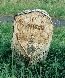
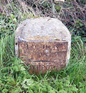
Milestones near Bourne, on the A151 north of the town (left)
and alongside the A15 to the south (right). |
The bleakest day was 30th May 1940, during the Second World War, when the government ordered that all direction signs that might aid an invading enemy be removed. This did not result in the loss of all milestones although many were taken away or vandalised but fortunately a lot were stored and re-erected and survive to this day, lovingly cared for by local authorities and through the efforts of enthusiastic people who are dedicated to their preservation and they serve as reminders of those days when travelling was entirely dependant on these markers to tell the passer-by exactly how far he had to go before reaching the next town or village.
Their preservation in the future is now assured because a Milestones Society has recently been formed to protect those that are left, mainly through the enthusiasm of Terry Keegan. "The idea is to have a strong body of interested individuals to make known the damage being done to our heritage by the neglect of these stones", he said. "We need to record them and to campaign for their preservation and upkeep. Many of the 250-year-old stones are still standing in some areas but there are many more over large areas of the country that have been so badly neglected and wilfully destroyed that to see one by the roadside in these places is a great rarity."
Most 17th and 18th century milestones are about 2 ft high and stone was the most commonly used material during this period but some are of cast iron and their date can usually be deduced by the lettering. They were usually made by local craftsmen and spelling on the earlier ones is often erratic. Abbreviations are also quite common. There are a number of well preserved cast iron milestones on the A15 near Folkingham which are marked with the names of the parishes in which they are situated and bearing the old spelling Falkingham and Bourn. Possibly the oldest milestone in this area is at Colsterworth; it is very worn and in known locally as a Roman milestone although its actual origins are uncertain.
|
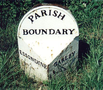
A
milestone on the grass verge of the A6121 Bourne to Stamford road,
marking the parish boundary between the villages of Essendine and
Carlby.
This
is an early 19th century example and note the old spelling of
Essendine. |
 |
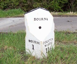
There are several in the immediate Bourne area although you do need to keep a weather eye open to see them. Two can be found within easy reach of the town and the largest of them dating from the 19th century is on A151 just opposite the Stamford turn announcing that Bourne is one mile and Colsterworth 11½ miles. A far more ancient milestone with a cast iron face plate fixed to the front of the stone and probably erected a century earlier, can be found on the A15 to the south of the town on the left hand side just past the now derelict Bourne Hospital although it might easily be missed because it is small and partly obscured by grass and weeds but its directions are still clear: London 96 miles and Deeping 6 miles. This milestone will almost certainly be within the orbit of the new road and roundabout system for the Elsea Park housing development on which work has now started but I understand that conservationists from Thurlby, who include it in their parish, are already at work seeking assurances that it will be preserved and if need be, moved to a similar and secure location in the immediate vicinity to protect it for the future.
|
HISTORIC MILESTONE VANDALISED
The ancient milestone on the A151 to the north of the town (pictured in
the box above) was restored in 2013 with the original spelling of BOURN
but within a few weeks someone had been busy with a pot of paint to add
the final "e" making the entire inscription a nonsense because the stone
pre-dates 1893 when the new spelling was introduced. |
 |
* Anyone who would like to know more about the Milestone Society should write to
Terry Keegan at The Oxleys, Tenbury Road, Clows Top, Kidderminster, Worcestershire DY14 9HE.

Go to:
Main Index Villages
Index
|