Street names
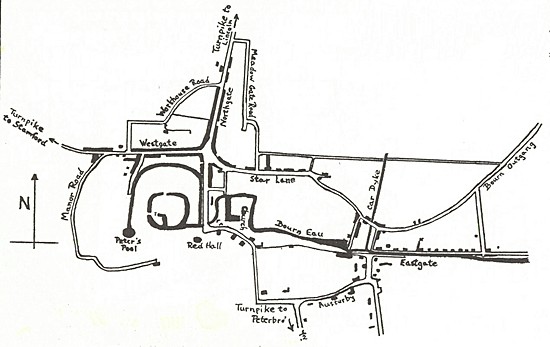
There are around 240 street names in Bourne, according to the latest town map, although the list is increasing annually and now forms a chronicle of our history because they reflect the people, places and events that have influenced the community over the centuries. When the town was little more than a
crossroads, there was no difficulty in naming the streets because they
were identified by the direction in which they ran, i e north, south, east
and west. As the town expanded, new streets were given names associated with nearby topographical features and so we had Church
Walk, Water Lane, Water Street, Brewery Lane, Meadow Close and Meadowgate, Water Lane and Union
Street, a reminder that there was once a workhouse here, later St Peter‘s
Hospital, demolished in 2001. This was a haphazard method of identifying streets that owed more to common usage than to official nomenclature while the numbering was often taken from the principal or most popular tavern or inn in that street, a system of location that had already been in use in previous centuries. The system was widespread through the country but all this began to change when the numbering of houses and naming of streets was officially introduced in England in 1805 after the government decided that they could be widely read as a result of improvements in the standard of education. The numbering of houses and the official
naming of streets that we know today was eventually introduced in Bourne
in 1899,
soon after the formation of Bourne Urban District Council. At one of the
first meetings of the new authority on Tuesday 13th June, Councillor John
Swift gave notice that he intended to move the advisability of naming the
streets and placing tablets on nearby walls or at other vantage points.
By October 1899, the committee appointed by Bourne Urban District Council to supervise the introduction of street names had become quite busy, not only naming new streets but also re-naming others to perpetuate the town's history and some of its worthy citizens. As a result, Star Lane became Abbey Road, to remember the Augustinian community that once lived here, Pinfold Lane became Hereward Street, Back Lane became Manning Road, after Robert Manning (1264-1340), the poet and chronicler who lived and worked at the abbey, and a section of Eastgate became Willoughby Road, one of the Ancaster family names while others are remembered with Ancaster Road and Drummond Road. Other names chosen by the committee included Stanley Street, after the famous explorer Henry Stanley, and Gladstone Street after the Victorian prime minister and statesman, William Gladstone. The committee also decided to number the houses in Stanley Street, Gladstone Street and Abbey Road. Other names whose origins are deeply rooted
in past history that have been added over the years are Bedehouse Bank, a reference
perhaps to an ancient monastic or prayer house that was once situated in
the vicinity, Coggles Causeway where the surface was paved with small
round stones or coggles, an alternative to cobblestones, the Austerby and
Christopher's Lane.
Today, most of the directional names remain
with North Street giving way to North Road as it leaves town, South Street
becoming South Road and West Street turning into West Road with Eastgate
almost a district on its own, as indeed it was in times
past. The tradition of naming new streets after kings and queens and prominent people soon became firmly entrenched and so we have royalty with Alexandra Terrace, Charles Close, Queen’s Road and Edinburgh Crescent, Princes Court, Kingsway, Victoria Place and George Street, politicians with Churchill Avenue, writers and poets with Kingsley Avenue, Tennyson Drive, Coleridge Place, Wordsworth Grove and Betjeman Close. There are also three thoroughfares named after hostelries situated in the vicinity, the Angel Precinct, off North Street, Crown Walk, off West Street, although the Crown closed in 1991 and the building incorporated in the present complex of shops and offices, and Granby Court which is close to the Marquis of Granby public house. The system of street naming remains more or less the same and although patriotic and military names are less evident today, there are special occasions when they are used. For instance, a housing development completed off Mill Drove in July 1994, was named to remember the Battle of Arnhem during the Second World War fifty years before in which troops were stationed in Bourne prior to the invasion. Places involved in the famous campaign have been commemorated with Arnhem Way, Oosterbeek Close, Lonsdale Grove, Barkston Close and Pegasus Grove and across the road the Burma campaign is remembered with Mountbatten Way, Arakan Way, Kohima Close, Mandalay Drive, Rangoon Way and Wingate Way.
The great and the good from Bourne’s history are also well represented: DELAINE CLOSE remembers Hugh Delaine Smith (1920-1995) and the family bus company that has served the town since 1890. He was awarded the MBE for services to public transport shortly before his death. HARRINGTON STREET after Robert Harrington (1589-1654), a local lad who walked to London and made his fortune which he left to the town and is now administered by Bourne United Charities. HARVEY CLOSE after Councillor Lacey E Harvey, a tailor, of 48 North Street, who was chairman of Bourne Urban District Council from 1932-33. LEYTONSTONE AVENUE and ESSEX WAY are named after that area of London where most of the property owned by Robert Harrington was located and still provides a large income for the benefit of the town.
MIDLETON GARDENS remembers Viscount Midleton (1903-88), best known
locally as Trevor Brodrick, who with his wife Sheila, did so much work for
deaf charities and the Girl Guides.
OSTLER DRIVE was named after John Lely Ostler (1811-59), wealthy
landowner and benefactor who helped found schools and assisted the poor
and who is remembered by a stone memorial in the town cemetery erected
after his death by public subscription. VICTOR WAY remembers Victor Wherry
(1913-88),
former chairman of the firm Wherry and Sons Ltd, using his first name
rather than the family name which was already in use elsewhere in the
town.
Street naming today is one of the tasks of the town council which is always called upon to advise housing developers. In March 2003, there was a controversy over the naming of new streets on the 2,000 home Elsea Park estate where house building was underway. There was a suggestion that the names should be linked to the town's motor racing heritage but the developers preferred Elsea Park Way, Aykroft, Cross Lane, The Pollards, The Yarde, Pond Lane and Quayside East and West, all of which have a modern and up market ring about them which was in keeping with the development. The Stamford Mercury tested public opinion and one resident suggested a whole tranche of names connected with the race track including Silverstone Drive, Goodwood Crescent, Pit Lane Walk, Brooklands Avenue and the names of famous drivers such as Stirling Moss and Jackie Stewart but in the event, the developers won the day although the motor racing idea was not sunk completely because one of the main perimeter roads was named Raymond Mays Way while Graham Hill Way on the Cherryholt Road industrial estate remembers the most famous of the BRM drivers, Graham Hill, who won the world championship in 1965. Cherryholt, often written as two words,
Cherry Holt, is generally accepted as meaning a place which is popular for
its cherries, as in Cherry Street (Birmingham) and Cherry Hinton
(Cambridgeshire), holt being a Lincolnshire word for wood or thicket. A
more precise definition, also from Cambridgeshire, is Cherry Willingham,
being the ham, or small settlement, of Willa's people in the place of the
cherry trees. The idea was fully discussed but discarded as future policy and members
decided to judge each case on its merits. In August 2003, the council
recommended street names with a medical connection for a new housing
estate of 70 homes then being built on the site of the old Bourne Hospital
in South Road opposite the Elsea Park development. Names of several general
practitioners who had served the town in past years were chosen including Holloway Avenue after Dr George Holloway
(1905-1967), Gilpin Close after Dr John Gilpin (1864-1943), Finn Close
after Dr Ruth Finn (1903-92), McKenzie Court after Dr Jean McKenzie (1925-1991), a visiting rheumatologist from Peterborough District Hospital, and Tipler Court after Mrs Florence Tipler
(1905-86) who worked at the hospital for many years as a senior nurse and
later served as chairman of Bourne Urban District Council from 1962-63.
Two popular highly respected district nurses during the middle years of
the 20th century, Sisters Edith Windle and Barbara Tully, are also
remembered with Windle Drive and Tully Close. Some streets remember other past landowners with Aveland Close and Heathcote Road, and past counties with Kesteven Way, Holland Close and Lyndsey Close (a misspelling of the correct name Lindsey), while there are also historical references such as Carholme Close. Many names still reflect topographical associations past and present such as Bourne Road, Ermine Close, Watling Close, Home Close, Lodge Road, Manor Court, Manor Lane, Northfields, Southfields, Tunnel Bank, Spalding Road, Station Approach, Stone Close, Waterside Close, Westbourne Park, Westminster Lane and Westwood Drive.
Bourne's reputation as a railway centre in years past is also remembered with Stephenson Way, built during the 1970s on land once occupied by the main line to Sleaford and named after George Stephenson, inventor of the Rocket steam engine and a leading figure of the new railway age during the early 19th century. Many natural features of the previous rural
landscape are remembered with Coppice Way, Greenacres Drive, Meadow Drove,
Mill Drove, Old Oak Place and Old Horse Chestnut Lane, the Slipe,
Springbank Drive and South Fen Road. The origins of several names, however, remain obscure and are most probably there at the whim of the builders, chosen because they were the titles of the development company involved or perhaps they described the house designs in that particular area. These include streets with hotel names such as Dorchester Avenue and Grosvenor Avenue, Beaufort Drive and Berkeley Drive, while others that remain unsolved include Dere Close, Brackley Close, Broadlands Avenue, Broadway Close, Burmor Close, Foxley Court, The Gables, Hamilton Close, Richardson Close, Rochester Court, Russell Way, Shipley Close, Stretham Way, Wetherby Close, Wexford Close, Cheriton Park and Wendover Mews.
REVISED MAY 2013
Go to: Main Index Villages Index
|